| |||||
|
Updated October 21, 2020
| |||||
| Introduction | |||||
|
Maps in Calflora Applications:
Calflora web applications utilize Google Maps for displaying points, lines and polygons.
All coordinates are in decimal latitude and longitude, WGS84 datum.
Polygon area calculations are performed with the Google Maps Geometry Library API
which provides methods based on spherical geometry.
This is a discussion of gridding techniques that could be used in the grid survey method of mapping plant populations. In the grid survey method, a target area is divided into grid cells, and the containing grid cell acts as a polygon for any recorded assessment or treatment. The focus is on the presence or absence of a plant in a cell, and (if present) abundance within a cell. The choice of gridding technique is important, especially if data from various nearby grid surveys is going to fit togehter well. It is possible to translate data made with one gridding technique into another gridding technique, but some data will likely be lost. | |||||
| Grids based on a Projection | |||||
Here is some basic information about projections:
... Teale-Albers: Projection error must not exceed 1.25%. Projection and Datum Guidelines, California Department of Fish and Wildlife (CDFW).
... California (Teale) Albers is an adaptation of the Albers Conical Equal Area projection as defined by the former State of California Teale Data Center. It is a California-specific projection optimized for area calculations, making it popular to map statewide resources. It may be referred to as "Teale Albers", [or] "California Albers", ... The projection divides California into four quadrants. Coordinate values (units of measure) are in meters from the origin (0,0) near the center of the state. 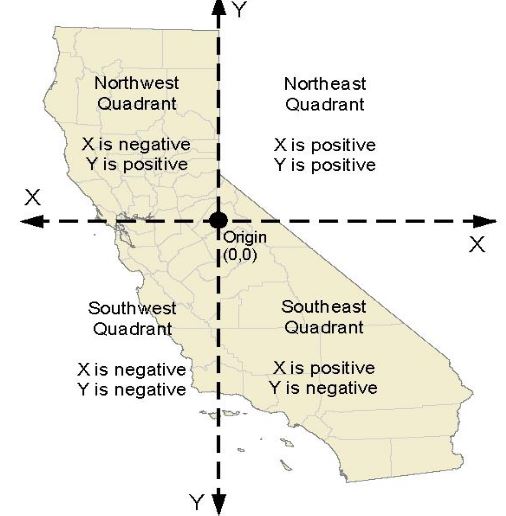
(See also Projections in States other than California below.) |
|||||
|
Discussion
CDFW recommends Teale Albers for statewide datasets.
The units are meters, so grid cell coordinates in this projection
would start as meters, and be mapped to geographic coordinates (latitude longitude) as necessary.
Because it is an equal area projection, the area of any two (for instance, 100m X 100m) grid cells
is essentially equal anywhere in the state.
Using a statewide projectiion like Teale Albers is definitely the industry standard approach. The fact that cells have an equal area is a big advantage: five grid cells in Del Norte County will have the same area as five grid cells in San Diego County. (Mountainous terrain will throw this equality off, but that is true for any gridding technique.) The disadvantage of using a gridding technique based on the Teale Albers projection is that it is not applicable outside of California. (Arguably Teale Albers would work in Nevada -- see the graphic above -- but it is not used in Nevada.) Each state has its own preferred projections with good reason -- see Projections in States other than California below. |
|||||
| Geographic Grids | |||||
|
In a geographic grid, the side of a grid cell is specified as a fraction
of a latitude/longitude degree.
In California latitudes, these cells appear on Google Maps as
vertically oriented rectangles: the vertical dimension appears greater than the horizontal dimension.
Examples: 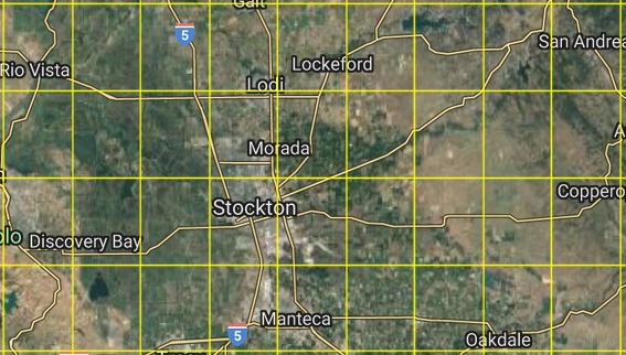
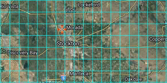
2. When a contributor obscures a record in Calflora, the point location is shown
as the center of the containing quarter quad. The side of a quarter quad grid cell is 1/16 of a degree:
3. Prism Climate Data is typically available as a geographic grid where the side of a grid cell is 1/120 of a degree, or 30 arc seconds: 
| |||||
|
Discussion
The advantage of geographic grid cells is that they are uniformly applicable
almost anywhere on the globe.
Also, the units are decimal degrees, so no translation is necessary when
coordinates come in from a GPS device. With this method, there is no need to choose a projection.
The disadvantage is that at a given resolution, the cells are not equal area. The area of a cell depends on its latitude. For instance, as per the discussion above, the area of a 1/120 degree cell at latitude 32.6 (San Diego) is 725,003 square meters; the area at latitude 42.0 (Del Norte) is 639,618 square meters. This is a variation of 11 %. If the area being gridded is not very big, then the fact that geographical grid cells are not equal area may not matter. But for purposes of statewide comparison (or even more so, national comparison), it may matter. | |||||
| Interlaced Metric Grids | |||||
|
An Interlaced Metric Grid (IMG) has some of the positive aspects of both
grids based on a projection and geographic grids.
Equal Area.
An IMG grid cell is absolutely square -- the height and the width are equal and specified in meters.
The resolution of the grid is specified as the length of the side of a cell in meters;
for instance, 2 kilometers. If the side of a cell is 2 kilometers, the area of the cell will be 4 square kilometers.
At a given resolution, the size of a grid cell is Units. For purposes of drawing a grid cell on a map, the units are geographic (latitude and longitude). For purposes of measuring the side of a grid cell or the area of a grid cell, the units are meters. Alignment. IMG utilizes the UTM projection to get the length in meters of a degree of longitude at any particular degree of latitude. At a given resolution, grid cells line up horizontally but not vertically. The horizontal spacing of cells depends on the length in meters of a degree of longitude at that particular latitude, which changes contiuously from the equator to the poles.
IMG cells at 5 km resolution: 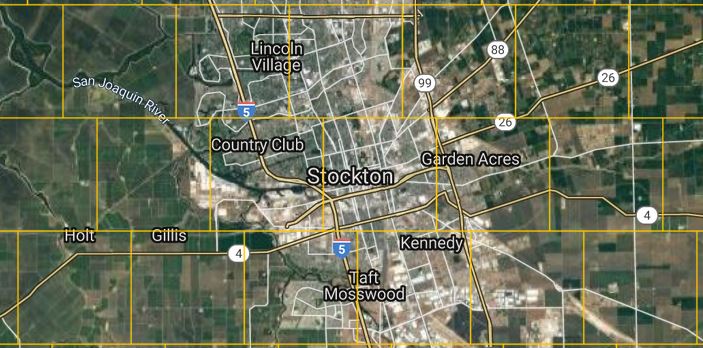
2 km resolution: 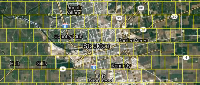
1 km resolution: 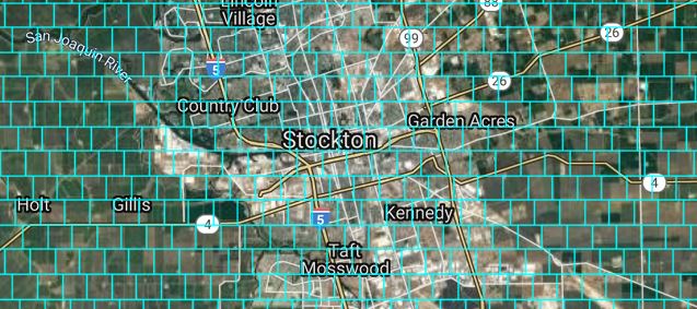
100 M resolution: 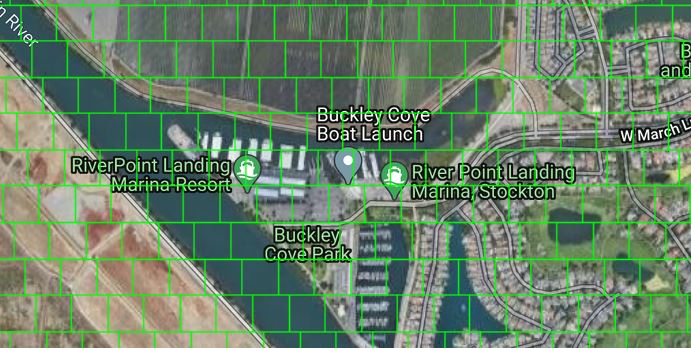
Cell ID. At a given resolution, a particular location specified as latitude and longitude resolves to a unique cell ID (the ID of the containing cell). For instance, 45.5162, -122.6836, the location of the Art Museum in downtown Portland, Oregon resolves to
2535:-4782:2K at 2 km; 5070:-9565:1K at 1 km; and 50693:-95667:100 at 100 meters.
Discussion
The advantage of interlaced metric grid cells is that they are equal area, and uniformly applicable
anywhere on the globe. A projection is not needed.
The disadvantage is that the cells do not line up vertically. |
|||||
| Notes | |||||
|
Projections in States other than California
A recent research direction is to use many low distortion map projections to cover a state. Here are some examples:
Oregon Coordinate Reference System,
Oregon Department of Transportation.
... The term low distortion refers to both the horizontal distortion from presenting a curved surface on a plane and the vertical distortion because these projections are also scaled to a regional height representative of the area to be covered.
| |||||
| Further Reading | |||||
|
Wikipedia: Discrete Global Grids
Open Geospatial Consortium (2017), "Topic 21: Discrete Global Grid Systems Abstract Specification". Document 15-104r5 version 1.0. A Discrete Global Grid System (DGGS) is designed as a framework for information as distinct from conventional coordinate reference systems originally designed for navigation. For a grid based global spatial information framework to operate effectively as an analytical system it should be constructed using cells that represent the surface of the Earth uniformly. This ensures that, at multiple resolutions, each cell has an equal probability of contributing to an analysis. A DGGS is a spatial reference system that uses a hierarchy of equal area tessellations to partition the surface of the Earth into grid cells or their analogous lattice points. In this way information recorded about phenomena at a location can be easily referenced to the explicit area of the associated cell, integrated with other cell values, and provides statistically valid summaries based on any chosen selection of cells. With equal area partitioning, spatial analysis can be replicated consistently anywhere on the Earth independent of resolution or scale. | |||||