| ||||||||||||||||||||||||
|
Updated February 8, 2022
With the
Place Names application
you can search for places in California by name, and see them on a map.
Once you find the place you are looking for, click trhough to open either
What Grows Here? or Observation Search at that location.
This application utilizes geographical feature data from the USGS Geographical Names Information System (GNIS), Greeninfo Network's California Protected Areas Database (CPAD), and the California Department of Fish and Wildlife's California Streams GIS dataset. Each geographical feature is assigned to a feature class following the GNIS model. You can limit search results to a particular feature class; for instance, Town, Park, Summit, or Stream. If you have any questions about this application, please contact |
||||||||||||||||||||||||
|
Search Criteria
|
||||||||||||||||||||||||
|
Results
The results appear simultaneously as points
on the map and in a table to the left of the map.
If you click on a ison
| ||||||||||||||||||||||||
|
What Grows Here?
Open the What Grows Here? application at the location.
Observation Search Open the Observation Search application at the location.
|
||||||||||||||||||||||||
|
Streams. If the feature is a stream
 the point location indicates the end of the stream.
For a river that flows to the ocean, the point location will appear right
where the river meets the ocean.
For a creek that flows into a river, you will see a name like
the point location indicates the end of the stream.
For a river that flows to the ocean, the point location will appear right
where the river meets the ocean.
For a creek that flows into a river, you will see a name like
Dutch Bill Creek / Russian River
and the point will appear at the end of Dutch Bill Creek -- that is,
just where Dutch Bill Creek meets the Russian River.
When you select a stream, the course of the stream is highlighted in dark blue on the map. If the selected stream flows into another stream, the course of that other stream is highlighted in green on the map. In the example above, the course of Dutch Bill Creek will be highlighted in dark blue, and the course of the Russian River will be highlighted in green. 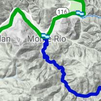
CPAD. If the feature is from the California Protected Areas Database, you will see ¹ next to the feature name:  Park ¹ Park ¹
|
||||||||||||||||||||||||
|
SYMBOLOGY
| ||||||||||||||||||||||||
|
Examples
Peaks in Orange Co.
Streams close to Auburn (North Fork American River) | ||||||||||||||||||||||||
|
Using the Application for Reseach
If you have an historic description of a place, and you want to find out where it is on a modern map,
you may be able to find it using this application. For instance, it works well for towns that no longer exist.
Another resource to use for researching historic place descriptions is GEO Locate. For more information about background layers, see Layer Help.
| ||||||||||||||||||||||||
|
RELEASE NOTES:
• June, 2019: v. 0.34: First public release. | ||||||||||||||||||||||||
 on the map,
an InfoWindow opens at the point,
the table scrolls down to
the corresponding record,
and the record is highlighted.
If you click on the purple crayon
on the map,
an InfoWindow opens at the point,
the table scrolls down to
the corresponding record,
and the record is highlighted.
If you click on the purple crayon  next to a record in the table,
an InfoWindow opens at
the corresponding map point,
and a short menu opens up under the record:
next to a record in the table,
an InfoWindow opens at
the corresponding map point,
and a short menu opens up under the record:


