|
|
GREAT PLACES | ||
| TO VIEW NATIVE PLANTS • HELP |
|
Updated December 27, 2021
The GREAT PLACES Project
If you are a Calflora contributor,
you can use the Great Places applications to highlight
your favorite places for viewing native plants.
Places include both wild locations and gardens where natives have been planted.
There are three component applications: a SEARCH page, a DETAIL page about a particular place, and an EDITOR for adding a new place. Great Places was developed with a generous grant from the JiJi Foundation. |
|||
|
Great Places Search
When the
Great Places Search
page first comes up,
it shows all great places in a table on the right.
Each place is also represented by a colored point on the map.
The various colors indicate the density of native plant observations at that location.
To view the details about a place, click on the name of the place in the table. An InfoWindow will appear on the map, showing where the place is, and with a link to the place detail page. Click this link to view the detail page for this place. (Alternatively, click on one of the points on the map. An InfoWindow will open showing the name of the place as a link. Click this link to view the detail page.) You can also click on the photo next to the name to go directly to the place detail page. |
|
||
|
Searching.
To search for particular places, enter a search term
(such as "forest" or "Tahoe") in the text box in the upper right, and press
. To limit the search to a particular part of the state,
zoom the map into that part, and check in map area.
To limit the search to the area covered by a particular CNPS Chapter,
click on the map inside of the chapter area.
The name of the chapter appears above the map on the right hand side.
Then check COLUMNS
The DENSITY column shows the number of native species per acre. A high value of density suggests that a visitor will be able to see many plants easily (in a small area). Click on NAME, AREA, or DENSITY to sort by that column. |
|||
|
Viewing a Great Place
Here is an example of a Great Place page:
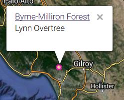
Byrne-Milliron Forest in Santa Cruz County, contributed by Lynn Overtree
and the Land Trust of Santa Cruz County.
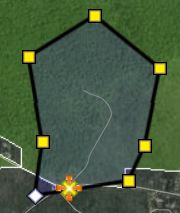
Exactly what you will see on a Great Place page depends on what the contributor chose to add. In this case, there is a paragraph about the place, landscape photos (example from Eileen Kitayama on the right), directions, hours, and tips (dogs are welcome!). There are also notes about trails, threats, and links to other websites for more information. Each Great Place should have a polygon boundary, which is shown on the map outlined in red.
Under  Shrub Shrub
The more local plant observations with photos there are, the more interesting
a place will appear. You can help document the plants at any one of the Great Places
by
|
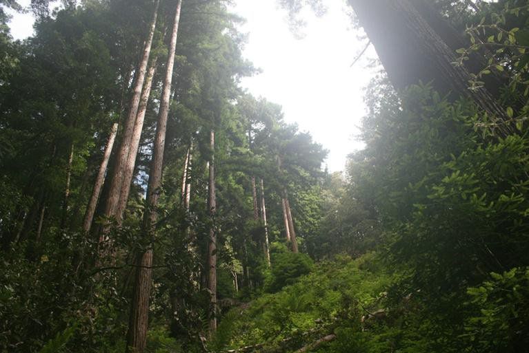
© 2015 Eileen Kitayama | ||
|
Examples:
Excellent description and landscape photos. A little thin on local plant photos (so far).
White's Hill Open Space:
Point Pinole:
Carson Pass:
Fern Canyon Area, Prairie Creek Redwoods State Park: |

Fern Canyon © 2014 William Flaxington | ||
|
Adding a Great Place
To add a Great Place, first register as a Calflora contributor.
You can do this on the
Calflora Home Page:
press LOGIN - REGISTER in the upper right and fill out the form.
It takes about a minute.
Once you are registered. open the Great Places Editor to add a place.
Press Add another Great Place.
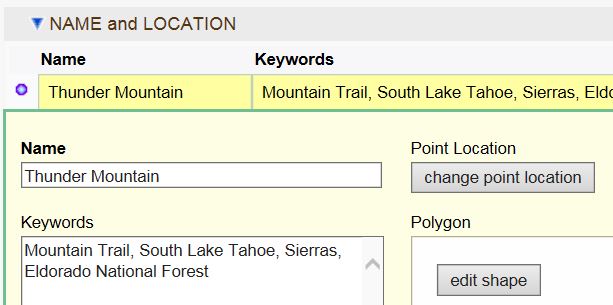
The NAME and LOCATION form appears.
Enter the name of your place.
To enter location, zoom the map in close to where your place is,
then press
These are the only two fields that are required. You can also draw a polygon, but if you don't, the application will generate a rectangular polygon around the point location. You can always edit this Great Place record later to fill in more details (such as keywords), or to correct what you have already entered. When you are ready, press the button. Next, the DESCRIPTION form appears, asking you to enter a short paragraph ABOUT this great place. This paragraph could include why this is a great place to see native plants. When you are ready, press the button. That's it -- you have just made a Great Place record. Press the VIEW THE PLACE PAGE link (top middle) to see what this place will look like to other users.
There are some large parks where it might take a week to explore all of the trails. In the case of a huge park, it would be better to choose two or three connecting trails as a Great Place, rather than to make a single Great Place for the whole park. When you are entering a Great Place, after you have draw or selected the polygon, press Calculate Area to find out the size of the polygon in acres. If the area is greater than 2,000 acres, it is probably too big.
Note that a link to the relevant CNPS Chapter will be automatically included in each Great Place. Each chapter is responsible for a certain area of the state. If the point location of your Great Place falls within the boundary of a chapter's area, a link to that chapter will be included.
When you come back to the
Great Places Editor
later, open
|
| ||
|
FAQ
Q:
TOO FEW PLANTS:
I just added a place. When I go to the Great Place page for my place and open  THE PLANTS, THE PLANTS,
The quickest way to get many plant observations into your place is to add a checklist, with the point location of the checklist inside the boundary polygon of your place. Use the Survey Entry application to add a checklist. If you already have a list of plants in an electronic form, you can use copy/paste to add them all at once. Q: INCORRECT PLANTS: I know the plants that grow at my place really well. When I go to the Great Place page for my place and open THE PLANTS,
Here is how to find the observation record numbers. Suppose you see Darlingtonia californica appear on your Great Place page in the perennial herb section, and you know that it does not actually grow at this place. On the Great Place page, click on the link, which takes you to an Observation Search search for native plant records within the polygon of your Great Place. Enter Darlingtonia californica in the Scientific Name field, and press . You should see the record numbers in the left most column called ID. When you write to Calflora, you can also simply include the URL of the Observation Search search. Q: How do I change the point location or the polygon of a place I have already added?
MY GREAT PLACES,
 to begin editing that place.
The NAME and LOCATION table appears.
Click on the purple dot
to open the form. to begin editing that place.
The NAME and LOCATION table appears.
Click on the purple dot
to open the form.
To change the point location, press . Your next click on the map will be the new point location. To change the polygon, press . You can add new vertices, move existing vertices, or delete existing vertices. When you are done, press and then . |
|
||
|
Q:
Why add a Great Place?
Here is what we are hoping to accomplish with the Great Places project. When a place appears in Great Places, contributors will be encouraged to make additional plant observations at that place. Over time, and through this kind of cooperative effort, the native plants in these places will become better documented. |
|||
|
Evolution of the Checklist
There has been an evolution of the way that Calflora handles checklist data over the last two decades.
In 2009 Calflora introduced the Checklist Entry application, with the ability to store a point location, a gross area, and a list of plants. The owner must explicitly edit the checklist record in order to change the plant list. In 2012 this application was enhanced with the ability to draw a polygon, and to calculate the area of the polygon. In 2016 this application was replaced by the Survey Entry application, with many additional features. With Great Places it is easier than ever to prepare a checklist of plants for a particular location. All the owner of a Great Place record has to do is to draw a polygon of a discrete area, and give the place a name. From then on, the Great Place record becomes an implicit checklist of all plants within that polygon. The list of plants is dynamic in the sense that any new observation record within the polygon will automatically become part of it. | |||
|
How Great Places are Used
1. Great Places suggest to other Calflora users places that are worth exploring, and which native plants
they might expect to find.
2. The EPA Ecoregions in California application includes descriptions of the vegetation of each Level IV ecoregion. For instance, for the Central Sierra Lower Montane Forests (5h) ecoregion it includes this description:
| |||
|
Release Notes
v. 0.65 September, 2021 v. 0.57 September, 2016
When you search for great places,
you will see the
AREA
(size of the polygon in acres) and
DENSITY
(number of native species per acre)
for each place found.
Click on
NAME,
AREA, or
DENSITY
to sort by that column.
| |||
 THE PLANTS